Enregistrez gratuitement cette image
en 800 pixels pour usage maquette
(click droit, Enregistrer l'image sous...)
|
|
Réf : T01202
Thème :
Terre vue de l'espace - Montagnes - Collines - Neige - Glace (539 images)
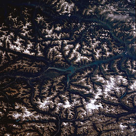
Titre : Columbia River, British Columbia, Canada August 1989
Description : (La description de cette image n'existe qu'en anglais)
The snow covered, ice formed peaks of the Canadian Rocky Mountains (parallel to the bottom of the picture) form the border between British Columbia (west or top) and Alberta (east or bottom). These elevated peaks, generally exceeding 10,000 feet (3,050 meters) above sea level, are part of the northern portion of the Continental Divide. The wider stretch of water in this part of the Columbia River is known as Kinbasket Lake (center). The two large snow capped peaks in the lower right quadrant of the image show the locations of the Clemenceau and Columbia Ice Fields in Alberta, where elevations exceed 12,000 feet (3,660 meters) above sea level.
|
|

