Enregistrez gratuitement cette image
en 800 pixels pour usage maquette
(click droit, Enregistrer l'image sous...)
|
|
Réf : T01546
Thème :
Terre vue de l'espace - Plaines - Plateaux - Vallées - Général (487 images)
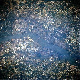
Titre : Savannah River, Georgia and South Carolina, U.S.A. April 1993
Description : (La description de cette image n'existe qu'en anglais)
The dark, heavily vegetated northwest-southeast-trending floodplain of the Savannah River is discernible across the rural terrain of eastern Georgia and southern South Carolina. The matted look of the landscape results from agricultural activities (varisized lighter areas) and darker, forested lands. Several circular cultivated field patterns indicate the use of center-pivot irrigation for farming. Southwest of the dark Salkehatchie River floodplain (top of photograph) is the U. S. Highway 301 bridge (barely visible left of center) that crosses the Savannah River northwest of Savannah and connects the small rural communities of Allendale, South Carolina, and Sylvania, Georgia
|
|

