Enregistrez gratuitement cette image
en 800 pixels pour usage maquette
(click droit, Enregistrer l'image sous...)
|
|
Réf : T01730
Thème :
Terre vue de l'espace - Plaines - Plateaux - Vallées - Général (487 images)
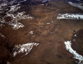
Titre : Great Divide Basin and Laramie and Bighorn Mountains, Wyoming, U.S.A. April 1994
Description : (La description de cette image n'existe qu'en anglais)
This panoramic, southwest-looking, low-oblique photograph features most of southern and southwestern Wyoming. Visible clockwise from the top are the Uinta Mountains of northern Utah and elongated Flaming Gorge Reservoir; the southern portion of the Wyoming Range and the Wind River Range; and the Bighorn Basin, Boysen Reservoir, Bighorn Mountains, southern Powder River Basin, and Teapot Dome. Barely discernible (bottom left) are the Glendo Reservoir and the Laramie Mountains, a prong of the northern Colorado Front Range. Extending into Wyoming from northern Colorado, southwest of the Laramie Mountains, are the Medicine Bow Mountains, named by the Indians because of the abundance of ash wood from which to make bows and arrows for hunting, and the Sierra Madre, noted for deposits of copper. Barely discernible (center of photograph) are Pathfinder Reservoir and, to its south, smaller Seminoe Reservoir.
|
|

