Enregistrez gratuitement cette image
en 800 pixels pour usage maquette
(click droit, Enregistrer l'image sous...)
|
|
Réf : T02539
Thème :
Terre vue de l'espace - Fleuves - Rivières - Lacs (517 images)
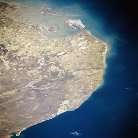
Titre : The Rio Negro, Argentina January 1997
Description : (La description de cette image n'existe qu'en anglais)
The Rio Negro, Argentina January 1997 Situated between Point Rasa to the east and Point Bermeja to the west, lies the mouth of the Rio Negro (midway between the center and right center of the image). The Rio Negro, 400 miles (645 km) long, is formed in central Argentina by the confluence of the Neuquen and Limay Rivers (not visible on the image) and flows generally eastward to the Atlantic Ocean. The river is used extensively for irrigation due to its location in the extreme southern pampas agricultural area of Argentina. As seen on the image, little sediment from the waters of the Rio Negro reaches its Atlantic Ocean mouth. At the upper left and upper center of the image, sediment from the Colorado River mouth is visible. Along the bottom left to bottom center, the waters of the northern portions of San Matias Gulf can be seen
|
|

