Enregistrez gratuitement cette image
en 800 pixels pour usage maquette
(click droit, Enregistrer l'image sous...)
|
|
Réf : T02745
Thème :
Terre vue de l'espace - Fleuves - Rivières - Lacs (517 images)
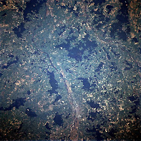
Titre : Allier River, Moulins, France October, 1994
Description : (La description de cette image n'existe qu'en anglais)
Allier River, Moulins, France October, 1994 The Allier River is visible traversing the image from the bottom center (south) to midway between the top left and top center in this northwest-looking view. The Allier River, navigable for most of its course, rises in the Cevennes Mountains of southeastern France and flows generally northwestward for 255 miles (410 km) joining the Loires River just west of Nevers, France (not visible on image). Located on east bank (right) of the Allier River near the bottom center of the image is the manufacturing city of Moulins. The city has remarkable artistic and historical treasures dating back to the 15th and 16th centuries. A highway loop is discernible surrounding the eastern half of the city. A portion of the Loire River, the longest river in France, is visible in the upper right quadrant of the image. The forested uplands (darker landscape) of the Langres Plateau are discernible in the upper right portion of the image.
|
|

