Enregistrez gratuitement cette image
en 800 pixels pour usage maquette
(click droit, Enregistrer l'image sous...)
|
|
Réf : V01638
Thème :
Terre vue de l'espace - Mers - Côtes - Caps - Péninsules (601 images)
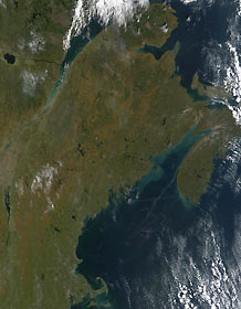
Titre : New England and Canada
Description : (La description de cette image n'existe qu'en anglais)
Fall color and a little bit of snow have come to the northeastern United States and Canada. In This true-color image from October 9, 2001, the burnt orange color of fading leaves and other vegetation is prominent in New Brunswick (top) and runs down through Maine, New Hampshire, and Vermont, especially in the higher elevations away from the Atlantic Coast. A cluster of white located left of center of the image indicates an early season snow fall.The St. Lawrence River runs from the left center edge of the image, northward to where it empties into the Gulf of St. Lawrence. The mouth of the river shows the characteristic brown of high sediment. The grayish cluster of pixels on the left of the river where it widens is the city of Quebec. Other prominent cities can be seen in the lower right of the image. West of the Cape Cod 'boot' of Massachusetts is Providence, Rhode Island. To its north is Boston.Between the southern end of Nova Scotia (right center edge) and the city of Portland, Maine, across the Bay of Fundy, a smoke plume might mark the path of the ferry that runs between Yarmouth and Portland. The blue-green color of the waters in the Bay likely indicate a bloom of phytoplankton. The highest tides on Earth occur in the Bay of Fundy in the Minas Basin, the eastern extremity of the Bay of Fundy, where the average tide range is 12 meters (nearly forty feet!) and has reached as high as 50 feet.
|
|

