Save this image free of charge
in 800 pixels for layout use
(right click, Save as...)
|
|
Ref : T01213
Theme :
Looking at Earth - Plains - Plateaus - Valleys (487 images)
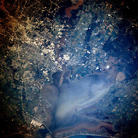
Title : Houston and Galveston Bay, Texas, U.S.A. August 1989
Caption :
Houston, located on the coastal plain of southeast Texas, is known as a leading industrial and manufacturing center and ranks as one of the top three port facilities in the United States. Large industrial processing plants along the east and southeast sides of downtown are shown as highly reflective areas, primarily along the Houston Ship Channel and as far south as Texas City (bottom left corner). Oceangoing ships from the Gulf of Mexico have access to the port of Houston through Galveston Bay, showing a complex pattern of surface currents and turbid plumes, and the Houston Ship Channel, an eastern extension of Buffalo Bayou that winds through downtown Houston. North of the city is muddy Lake Houston, part of the San Jacinto River system that empties into the eastern end of the Houston Ship Channel near the northwest corner of Galveston Bay. The elongated island at this intersection is the result of dumping dredged materials from the Houston Ship Channel. To the east, the Trinity River with its swampy, lake-filled estuary (including oval Lake Anahuac) flows into Trinity Bay, which makes up the northeast segment of Galveston Bay. The extensive sediment patterns in Trinity Bay and Galveston Bay probably resulted from a recent rainstorm.
|
|

