Enregistrez gratuitement cette image
en 800 pixels pour usage maquette
(click droit, Enregistrer l'image sous...)
|
|
Réf : T01385
Thème :
Terre vue de l'espace - Plaines - Plateaux - Vallées - Général (487 images)
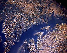
Titre : Chesapeake Bay, Maryland and Virginia, U.S.A. June 1991
Description : (La description de cette image n'existe qu'en anglais)
This northwest-looking, low-oblique photograph shows the blue waters of the middle portion of Chesapeake Bay, the largest estuary in the United States. The cities of Washington, DC, and Baltimore are visible west of the bay. The bay, an inlet of the Atlantic Ocean, is 200 miles (320 kilometers) long, 3 to 30 miles (5 to 48 kilometers) wide, and separates the Delmarva Peninsula to the east from the mainland to the west. The bay begins at the mouth of the Susquehanna River and is fed by as many as 150 rivers and small streams, including the Potomac, the Patuxent, the Rappahannock, and the James. Despite increased urbanization and farming during the last 6 decades that have resulted in serious deterioration of the water quality and a reduction in the number of fish and other aquatic organisms, Chesapeake Bay is home to one of the most productive ecosystems in the world. State and local governments are enacting policies to help alter the water quality deterioration in the bay. The bay is used for sports and other recreational activities as well as commercial fishing. It is also an important part of the Intracoastal Waterway.
|
|

