Save this image free of charge
in 800 pixels for layout use
(right click, Save as...)
|
|
Ref : T02867
Theme :
Looking at Earth - Rivers - lakes (517 images)
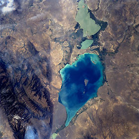
Title : Lake Alakol, Kazakhstan August 1977
Caption :
Lake Alakol, Kazakhstan August 1977. Lake Alakol (center of image), located in east central Kazakhstan, is the northwest extension of the region known as the Dzungarian Gate. This narrow valley (top center) connects the southern uplands of Kazakhstan with arid northwest China. The Dzungarian Gate is a fault-bounded valley (see vertical line on the image along the southwest side of the lake) where the elevation of the valley floor is about 1500 feet (457 meters) above sea level and the peaks of the Dzungarskiy Alatau Range (upper right) reach 15000 feet (4572 meters) above sea level. Two, well-defined alluvial fans are visible where mountain streams cut through the faulted landscape (southwest side of lake). Lake Alakol, a salt lake, has a drainage basin of approximately 26500 square miles (68700 sq. km) and receives water periodically from the southerly draining Urdzhar River at the north end of the lake. The surface area of the lake is roughly 1025 square miles (2655 sq. km) and is about 148 feet (45 meters) deep at its maximum depth. A swampy, lowland connects the northwest end of Lake Alakol with the lighter-colored Lake Sasykkol (bottom center). Agricultural activity in this arid region is limited to areas where adequate moisture is available, mainly along ephemeral streambeds and in the deltas and alluvial fans
|
|

