Enregistrez gratuitement cette image
en 800 pixels pour usage maquette
(click droit, Enregistrer l'image sous...)
|
|
Réf : T01112
Thème :
Terre vue de l'espace - Fleuves - Rivières - Lacs (517 images)
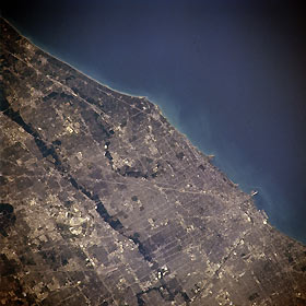
Titre : Lake Michigan and Chicago, Illinois, U.S.A. Winter 1995-1996
Description : (La description de cette image n'existe qu'en anglais)
Lake Michigan; central and northern Chicago; and the dark, north-south-trending Des Plaines River Valley are apparent in this north-northeast-looking, low-oblique photograph. Most of Chicago east of the Des Plaines River rests on the flat floor of ancestral Lakes Chicago and Nipissing—predecessors of Lake Michigan. Chicago, the nation’s third largest city, is the commercial, financial, industrial, and cultural center for a vast region and a large midcontinental transportation and shipping point. The city covers more than 200 square miles (520 square kilometers) and extends more than 25 miles (40 kilometers) along Lake Michigan. Three airports are encompassed in this photograph—Chicago-O’Hare International (barely discernible, lower left), one of the busiest airports in the world; Glenview Naval Air Station between the Des Plaines and Chicago Rivers (above center); and Chicago Midway (barely discernible midway between bottom center and bottom right). (Refer to NM21-765-043 for a photograph of south Chicago.)
|
|

