Enregistrez gratuitement cette image
en 800 pixels pour usage maquette
(click droit, Enregistrer l'image sous...)
|
|
Réf : S14349
Thème :
Terre vue de l'espace - Volcans (181 images)
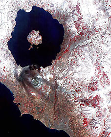
Titre : Mt. Usu, Japan
Description : (La description de cette image n'existe qu'en anglais)
April 3, 2000 image of the erupting Mt. Usu volcano in Hokkaido, Japan. This false color infrared image, covering an area of 18 km (13 miles) by 22 km (15 miles), of Mt Usu volcano is dominated by Lake Toya, an ancient volcanic caldera. On the south shore is the active Usu volcano. On Friday, March 31, more than 11,000 people were evacuated by helicopter, truck and boat from the foot of Usu, that began erupting from the northwest flank, shooting debris and plumes of smoke streaked with blue lightning thousands of feet in the air. Although no lava gushed from the mountain, rocks and ash continued to fall after the eruption. The region was shaken by thousands of tremors before the eruption. People said they could taste grit from the ash that was spewed as high as 2,700 meters (8,850 ft) into the sky and fell to coat surrounding towns with ash. ''Mount Usu has had seven significant eruptions that we know of, and at no time has it ended quickly with only a small scale eruption'', said Yoshio Katsui, a professor at Hokkaido University. This was the seventh major eruption of Mount Usu in the past 300 years. Fifty people died when the volcano erupted in 1822, its worst known eruption. In the image, most of the land is covered by snow. Vegetation, appearing red in the false color compoiste, can be seen in the agricultural fields, and forests in the mountains. Mt. Usu is crossed by three dark streaks. These are the paths of ash deposits that rained out from eruption plumes two days earlier. The prevailing wind was from the northwest, carrying the ash away from the main city of Date. Ash deposited can be traced on the image as far away as 10 kilometers (16 miles) from the volcano. RIGHT: On April 5 the satellite captured this night time thermal infrared image of Mt. Usu. Hot thermal anomalies, appearing as bright spots, are seen on the west flank of Usu, site of the eruptions. Additional hot spots appear at the summit, and at a vent on the east flank.
|
|

