Enregistrez gratuitement cette image
en 800 pixels pour usage maquette
(click droit, Enregistrer l'image sous...)
|
|
Réf : T01332
Thème :
Terre vue de l'espace - Failles (69 images)
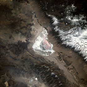
Titre : Owens Lake, California, U.S.A. May 1991
Description : (La description de cette image n'existe qu'en anglais)
Before an aqueduct was built to divert water from the Owens River to the city of Los Angeles for its water needs, Owens Lake (center of the photograph) held water in a basin 18 miles (29 kilometers) long and nearly 10 miles (16 kilometers) wide. This south-southwest-looking, low-oblique photograph reveals a dry Lake Owens, north and south of which is seen the Owens River, 120 miles (195 kilometers) long, rising in the Sierra Nevada southeast of Yosemite National Park. West of Owens Lake are snow-covered peaks of the Sierra Nevada and Mount Whitney, the highest mountain in the conterminous United States at 14 494 feet (4421 meters), part of Sequoia National Park. The Inyo Mountain Range and the dark blue waters of the Haiwee Reservoir lie northeast and south, respectively, of Owens Lake.
|
|

