Enregistrez gratuitement cette image
en 800 pixels pour usage maquette
(click droit, Enregistrer l'image sous...)
|
|
Réf : T01611
Thème :
Terre vue de l'espace - Failles (69 images)
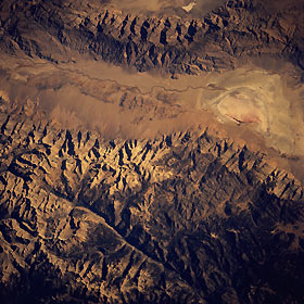
Titre : Owens Valley, California, U.S.A. October 1993
Description : (La description de cette image n'existe qu'en anglais)
The main channel of the south-flowing Owens River is discernible as a narrow, meandering line in this near-vertical photograph that shows a 50-mile (80-kilometer) section of the Owens Valley. The Owens River enters oval, lighter Owens Lake, a source of potable water for the city of Los Angeles since the early 1900s. This fault valley is flanked by the Sierra Nevada Mountains on the west and the smaller Inyo Mountains on the east. The darker, linear, north-south-trending feature near the western edge of the photograph is part of the Kern River Valley, another fault valley. Mount Whitney, the highest peak in the 48 contiguous states at 14 495 feet (4415 meters), is located between these two valleys.
|
|

