Enregistrez gratuitement cette image
en 800 pixels pour usage maquette
(click droit, Enregistrer l'image sous...)
|
|
Réf : T01130
Thème :
Terre vue de l'espace - Forêts (124 images)
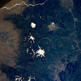
Titre : Mount Saint Helens, Mount Adams, and Mount Rainier; Washington; U.S.A. Winter 1995-1996
Description : (La description de cette image n'existe qu'en anglais)
The southern Washington Cascade Range is visible in this near-vertical photograph. The Columbia River, separating the states of Oregon and Washington, can be seen at the top of the photograph. The second-highest peak in the Cascade Range, Mount Adams, is visible north of the river. The horseshoe-shaped summit and caldera of Mount Saint Helens and the gray blast zone from its eruption of May 18, 1980, can be seen west of Mount Adams. North of Mount Adams and Mount Saint Helens is Mount Rainier, the highest peak in the Cascade Range and the second highest peak in the contiguous United States. Puget Sound and the cities of Olympia, Tacoma, and Seattle are visible near the bottom right, and the city of Yakima is barely discernible near the center left.
|
|

