Enregistrez gratuitement cette image
en 800 pixels pour usage maquette
(click droit, Enregistrer l'image sous...)
|
|
Réf : V02145
Thème :
Terre vue de l'espace - Villes (375 images)
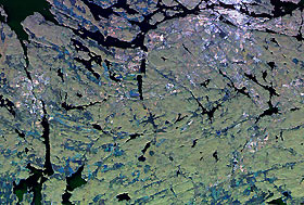
Titre : Stockholm, Sweden
Description : (La description de cette image n'existe qu'en anglais)
The flat, glaciated region that surrounds the city of Stockholm, Sweden is shown on this radar image. The southern portion of this capital city is the bright area in the upper right of the image. Dark areas on the image show where water crisscrosses the region, forming thousands of islands that comprise the Stockholm archipelago. Green areas on the image are vegetation, blue areas have been partially cleared and white areas are urban and other settlements. The area shown is 27 by 40 kilometers (16 by 25 miles) centered at 59.2 degrees north latitude, 17.9 degrees east longitude. Colors are assigned to different radar frequencies and polarizations as follows: red is L-band horizontally transmitted, horizontally received; green is L-band vertically transmitted and vertically received; blue is C-band vertically transmitted and vertically received. The image was acquired by the Spaceborne Imaging Radar-C/X-band Synthetic Aperture (SIR-C/X-SAR) imaging radar when it flew aboard the space shuttle Endeavour on October 2, 1994. SIR-C/X-SAR is a joint mission of the U.S./German and Italian space agencies.
|
|

